The landlab contract’s reference event (WA4818312053120240608), in three steps:
Stage every dataset the landlab workflow reads into one Zarr store, each on its native grid.
Align the store onto the contract’s 10 m UTM grid with
gaia align, and look at it.Convert the aligned store to GeoTIFF and ESRI ASCII grids with GDAL alone (scripts
/landlab -inputs .sh).
The soil-derived node fields (porosity, cohesion, ...) are not computed here: landlab_data_prep derives them from the seven SOLUS layers.
from pathlib import Path

import geopandas as gpd
import matplotlib.pyplot as plt
import numpy as np
import pandas as pd
import rasterio
import rioxarray  # noqa: F401  registers .rio
import xarray as xr
from matplotlib.colors import LightSource, to_rgba
from matplotlib.patches import Patch

from zarr.storage import ObjectStore
from obstore.store import S3Store

from gaia_cli import stations

#%config InlineBackend.figure_format = 'retina'
1. Stage
examplesfire and year choose the 2024 Pioneer Fire. The stores go to the scratch/public prefix on Kopah, which anyone can read and which is deleted after 2 weeks; the landlab files go to /tmp.
!cat pioneer.yaml# Pioneer Fire, WA (2024): the landlab workflow's reference event. Its required inputs
# (DEM, burn severity, SOLUS soil, STATSGO K-factor, land cover), plus station and PRISM
# precipitation for the December 2025 atmospheric river. Check with --dry-run, then stage:
# gaia stage --config examples/pioneer.yaml --dry-run
# gaia stage --config examples/pioneer.yaml -o /tmp/pioneer
# pioneer-landlab.ipynb aligns the result onto the landlab grid over the same AOI.
name: pioneer
attrs:
title: Pioneer Fire landlab inputs, with the December 2025 atmospheric river
aoi: pioneer-aoi.geojson # relative to this file; also gaia align --aoi
window: 2025-12-01/2025-12-16 # whole days, end included; static layers ignore it
datasets:
dem/usgs10m: {}
burn-severity: {fire: pioneer, year: 2024} # the AOI meets five BAER fires
soil/solus100: {}
soil/statsgo: {}
nlcd: {year: 2021}
prism: {variables: [ppt, tmin, tmax]}
synoptic: {}
scratch = "s3://gaia/scratch/public"
staged = f"{scratch}/pioneer"                # gaia stage -o
aligned = f"{scratch}/pioneer-10m"           # gaia align -o
staged_zarr = f"{staged}/pioneer.zarr"       # gaia align -i
aligned_zarr = f"{aligned}/pioneer-10m.zarr"
# GDAL reads scratch/public anonymously through /vsis3/: with /vsicurl/, its search for
# dimension arrays outside the store prints ~100 warnings (dev/gdal-zarr/upstream-issue.md)
gdal_env = "AWS_S3_ENDPOINT=s3.kopah.uw.edu AWS_NO_SIGN_REQUEST=YES AWS_VIRTUAL_HOSTING=FALSE"
aligned_vsis3 = "/vsis3/" + aligned_zarr.removeprefix("s3://")
landlab_dir = "/tmp/pioneer-landlab"         # Landlab needs local files
!gaia stage --config pioneer.yaml -o {staged} --overwrite11:52:28 [ 1.2s] stagefile: Wrote s3://gaia/scratch/public/pioneer/stage.yaml
11:52:28 [ 1.2s] runner: dem/usgs10m: loading (static)
11:52:28 [ 1.2s] datasets.dem: DEM: opening https://prd-tnm.s3.amazonaws.com/StagedProducts/Elevation/13/TIFF/USGS_Seamless_DEM_13.vrt
11:52:33 [ 6.0s] io: Writing Zarr to s3://gaia/scratch/public/pioneer/pioneer.zarr
11:52:37 [ 10.4s] io: Saved s3://gaia/scratch/public/pioneer/pioneer.zarr
11:52:37 [ 10.6s] io: Wrote STAC item s3://gaia/scratch/public/pioneer/pioneer.json
11:52:37 [ 10.6s] runner: burn-severity: loading (static)
11:52:38 [ 11.4s] datasets.burn_severity: BAER: pioneer_wa4818312053120240608_sbs (2024)
11:52:44 [ 16.9s] datasets.burn_severity: BAER: exporting raster 3727 (1092 x 1656 cells)
11:52:47 [ 19.8s] io: Writing Zarr to s3://gaia/scratch/public/pioneer/pioneer.zarr
11:52:50 [ 23.8s] io: Saved s3://gaia/scratch/public/pioneer/pioneer.zarr
11:52:51 [ 23.9s] io: Wrote STAC item s3://gaia/scratch/public/pioneer/pioneer.json
11:52:51 [ 23.9s] runner: soil/solus100: loading (static)
11:52:51 [ 23.9s] datasets.soil: SOLUS: opening https://storage.googleapis.com/solus100pub/anylithicdpt_cm_p.tif
11:52:51 [ 24.6s] datasets.soil: SOLUS: opening https://storage.googleapis.com/solus100pub/cec7_0_cm_p.tif
11:52:52 [ 25.0s] datasets.soil: SOLUS: opening https://storage.googleapis.com/solus100pub/claytotal_0_cm_p.tif
11:52:52 [ 25.4s] datasets.soil: SOLUS: opening https://storage.googleapis.com/solus100pub/dbovendry_0_cm_p.tif
11:52:52 [ 25.7s] datasets.soil: SOLUS: opening https://storage.googleapis.com/solus100pub/ph1to1h2o_0_cm_p.tif
11:52:53 [ 26.0s] datasets.soil: SOLUS: opening https://storage.googleapis.com/solus100pub/sandtotal_0_cm_p.tif
11:52:53 [ 26.3s] datasets.soil: SOLUS: opening https://storage.googleapis.com/solus100pub/silttotal_0_cm_p.tif
11:52:53 [ 26.7s] io: Writing Zarr to s3://gaia/scratch/public/pioneer/pioneer.zarr
11:52:59 [ 32.7s] io: Saved s3://gaia/scratch/public/pioneer/pioneer.zarr
11:52:59 [ 32.8s] io: Wrote STAC item s3://gaia/scratch/public/pioneer/pioneer.json
11:52:59 [ 32.8s] runner: soil/statsgo: loading (static)
11:52:59 [ 32.8s] datasets.soil: STATSGO: opening https://prod-is-usgs-sb-prod-publish.s3.amazonaws.com/6750c172d34ed8d3858534d8/statsgo-KFFACT.tif
11:53:00 [ 33.4s] io: Writing Zarr to s3://gaia/scratch/public/pioneer/pioneer.zarr
11:53:06 [ 38.9s] io: Saved s3://gaia/scratch/public/pioneer/pioneer.zarr
11:53:06 [ 39.0s] io: Wrote STAC item s3://gaia/scratch/public/pioneer/pioneer.json
11:53:06 [ 39.0s] runner: nlcd: loading (static)
11:53:06 [ 39.0s] datasets.nlcd: NLCD: opening https://usgs.osn.mghpcc.org/hytest/nlcd/annual-nlcd-cu-c1v1/mosaic/Annual_NLCD_LndCov_2021_CU_C1V1.tif
11:53:10 [ 43.5s] io: Writing Zarr to s3://gaia/scratch/public/pioneer/pioneer.zarr
11:53:16 [ 49.7s] io: Saved s3://gaia/scratch/public/pioneer/pioneer.zarr
11:53:16 [ 49.8s] io: Wrote STAC item s3://gaia/scratch/public/pioneer/pioneer.json
11:53:16 [ 49.8s] runner: prism: loading (2025-12-01T00:00:00/2025-12-17T00:00:00, read as 2025-11-30T00:00:00/2025-12-18T00:00:00)
11:53:17 [ 50.0s] prism_cache.cache: PRISM ppt: 18 of 18 grid(s) in cache https://s3.kopah.uw.edu/gaia/public/prism (0 provisional, 0 missing)
11:53:17 [ 50.2s] prism_cache.cache: PRISM tmin: 18 of 18 grid(s) in cache https://s3.kopah.uw.edu/gaia/public/prism (0 provisional, 0 missing)
11:53:17 [ 50.3s] prism_cache.cache: PRISM tmax: 18 of 18 grid(s) in cache https://s3.kopah.uw.edu/gaia/public/prism (0 provisional, 0 missing)
11:53:17 [ 50.5s] datasets.prism: PRISM ppt: reading 18 day(s) x 36 x 35 cells from cached COGs
11:53:23 [ 56.2s] datasets.prism: PRISM tmin: reading 18 day(s) x 36 x 35 cells from cached COGs
11:53:35 [ 68.4s] datasets.prism: PRISM tmax: reading 18 day(s) x 36 x 35 cells from cached COGs
11:53:47 [ 80.4s] io: Writing Zarr to s3://gaia/scratch/public/pioneer/pioneer.zarr
11:53:55 [ 88.5s] io: Saved s3://gaia/scratch/public/pioneer/pioneer.zarr
11:53:55 [ 88.7s] io: Wrote STAC item s3://gaia/scratch/public/pioneer/pioneer.json
11:53:55 [ 88.7s] runner: synoptic: loading (2025-12-01T00:00:00/2025-12-17T00:00:00, read as 2025-11-30T00:00:00/2025-12-18T00:00:00)
11:53:55 [ 88.7s] datasets.synoptic: querying station metadata from https://api.synopticdata.com/v2
11:53:55 [ 88.8s] datasets.synoptic: found 4 stations with precip_accum in the AOI
11:53:55 [ 88.8s] datasets.synoptic: fetching timeseries for 4 station(s)
11:53:56 [ 89.1s] io: Writing Zarr to s3://gaia/scratch/public/pioneer/pioneer.zarr
11:54:05 [ 98.5s] io: Saved s3://gaia/scratch/public/pioneer/pioneer.zarr
11:54:05 [ 98.8s] io: Wrote STAC item s3://gaia/scratch/public/pioneer/pioneer.json
11:54:05 [ 98.8s] runner: Done
2. Align onto the contract grid
--crs utm --res 10 --aoi gives the contract’s grid: the UTM zone of the AOI (EPSG:32610), 10 m cells, the AOI’s bounds snapped outward to multiples of 10 m, and NaN in cells whose centre is outside the AOI. The -m options are the contract’s resampling methods; without them, DEMs use bilinear and categories mode. PRISM goes nearest (its default, conservative, becomes nearest onto a finer grid), and Synoptic’s stations pass through unchanged.
!gaia align -i {staged_zarr} -o {aligned} \
    --crs utm --res 10 --aoi pioneer-aoi.geojson \
    -m dem/usgs10m=cubic \
    -m soil/solus100=bilinear \
    -m rasters/nlcd=nearest \
    -m rasters/burn-severity=nearest \
    -m rasters/prism/tmin=bilinear \
    -m rasters/prism/tmax=bilinear \
    --overwrite
11:54:08 [ 2.4s] align: time target rasters/prism (18 step(s))
11:54:12 [ 5.8s] align: grid target EPSG:32610 at 10.0 (3309 x 2182 cells)
11:54:12 [ 5.8s] align: regridding dem/usgs10m/elevation (cubic)
11:54:15 [ 8.9s] align: regridding rasters/burn-severity/burn_severity (nearest)
11:54:18 [ 11.6s] align: regridding rasters/nlcd/landcover (nearest)
11:54:19 [ 13.1s] align: regridding rasters/prism/precipitation (nearest)
11:54:22 [ 15.8s] align: regridding rasters/prism/tmax (bilinear)
11:54:27 [ 20.6s] align: regridding rasters/prism/tmin (bilinear)
11:54:32 [ 25.8s] align: regridding soil/solus100/anylithicdpt (bilinear)
11:54:34 [ 28.3s] align: regridding soil/solus100/cec7 (bilinear)
11:54:37 [ 30.7s] align: regridding soil/solus100/claytotal (bilinear)
11:54:39 [ 33.1s] align: regridding soil/solus100/dbovendry (bilinear)
11:54:42 [ 35.6s] align: regridding soil/solus100/ph1to1h2o (bilinear)
11:54:44 [ 38.0s] align: regridding soil/solus100/sandtotal (bilinear)
11:54:47 [ 40.4s] align: regridding soil/solus100/silttotal (bilinear)
11:54:49 [ 43.0s] align: regridding soil/statsgo/kffact (nearest)
11:54:53 [ 47.2s] io: Writing Zarr to s3://gaia/scratch/public/pioneer-10m/pioneer-10m.zarr
11:56:04 [ 118.3s] io: Saved s3://gaia/scratch/public/pioneer-10m/pioneer-10m.zarr
11:56:05 [ 118.4s] io: Wrote STAC item s3://gaia/scratch/public/pioneer-10m/pioneer-10m.json
11:56:05 [ 118.4s] align: Done
# Kopah (Ceph) S3 access. obstore needs the endpoint explicitly, and path-style requests.
# Anything under scratch/public/ is anonymously readable, so no credentials needed
s3gaia = S3Store(
    bucket="gaia",
    prefix=aligned_zarr.removeprefix("s3://gaia/"),
    endpoint="https://s3.kopah.uw.edu",
    region="us-west-2",  # not actually used with kopah
    virtual_hosted_style_request=False,
    skip_signature=True, # anonymous read-only access
)

# Zarr-aware handler for reading from S3
gaia_zarr_store = ObjectStore(s3gaia, read_only=True)
dt = xr.open_datatree(gaia_zarr_store, engine="zarr", zarr_format=3, consolidated=True)
dt.groups('/',
'/dem',
'/rasters',
'/soil',
'/stations',
'/dem/usgs10m',
'/rasters/burn-severity',
'/rasters/nlcd',
'/rasters/prism',
'/soil/solus100',
'/soil/statsgo',
'/stations/synoptic')A look at the aligned store
def categories(da, min_share=0.005, by_share=True):
    """RGBA image and legend handles from a categorical variable's CF flag attributes."""
    codes = da.attrs["flag_values"]
    names = da.attrs["flag_meanings"].split()
    colors = da.attrs["flag_colors"].split()
    rgba = np.ones(da.shape + (4,))  # white where there's no class
    handles = []
    for code, name, color in zip(codes, names, colors):
        cells = (da == code).values
        rgba[cells] = to_rgba(color)
        share = cells.sum() / da.notnull().sum().item()
        if share >= min_share:
            handles.append((share, Patch(color=color, label=f"{name.replace('_', ' ')} ({share:.0%})")))
    if by_share:
        handles.sort(key=lambda h: -h[0])
    return rgba, [h for _, h in handles]


elevation = dt["dem/usgs10m"].elevation
soil = dt["soil/solus100"]
prism = dt["rasters/prism"].sel(time=slice("2025-12-01", "2025-12-16"))
precip = prism.precipitation.sum("time", min_count=1)

# Gauge totals over the same PRISM days (12:00 UTC to 12:00 UTC)
t0, t1 = prism.time_bounds.values[0, 0], prism.time_bounds.values[-1, 1]
hourly = stations.to_grid(dt["stations/synoptic"].to_dataset(), freq="1h", how="sum")
gauge_total = hourly.precipitation.sel(time=slice(t0 + np.timedelta64(1, "h"), t1)).sum("time", min_count=1)
xy = gpd.GeoSeries(hourly.geometry.values, crs="EPSG:4326").to_crs(precip.rio.crs)

fig, axes = plt.subplots(2, 3, figsize=(15, 11), layout="constrained", sharex=True, sharey=True)
x, y = elevation.x.values, elevation.y.values
extent = [x[0] - 5, x[-1] + 5, y[-1] - 5, y[0] + 5]

ax = axes[0, 0]
shade = LightSource(azdeg=315, altdeg=45).hillshade(elevation.fillna(elevation.min()).values, dx=10, dy=10)
ax.imshow(np.where(elevation.notnull(), shade, np.nan), extent=extent, cmap="gray")
elevation.plot.imshow(ax=ax, cmap="terrain", alpha=0.5, cbar_kwargs={"label": "m (NAVD88)", "shrink": 0.6})
ax.set_title("3DEP 10 m elevation (cubic)")

# burn severity's classes are ordered, NLCD's are listed by area
for ax, da, by_share, title in [
    (axes[0, 1], dt["rasters/burn-severity"].burn_severity, False, "Soil burn severity, Pioneer 2024 (nearest)"),
    (axes[0, 2], dt["rasters/nlcd"].landcover, True, "NLCD 2021 land cover (nearest)"),
]:
    rgba, handles = categories(da, by_share=by_share)
    ax.imshow(rgba, extent=extent)
    ax.legend(handles=handles, loc="lower left", fontsize=7, framealpha=0.9)
    ax.set_title(title)

(soil.anylithicdpt / 100).plot.imshow(ax=axes[1, 0], cmap="YlOrBr", cbar_kwargs={"label": "m", "shrink": 0.6})
axes[1, 0].set_title("SOLUS depth to bedrock (bilinear)")
dt["soil/statsgo"].kffact.plot.imshow(ax=axes[1, 1], cmap="viridis", cbar_kwargs={"label": "K-factor", "shrink": 0.6})
axes[1, 1].set_title("STATSGO K-factor (nearest)")

ax = axes[1, 2]
precip.plot.imshow(ax=ax, cmap="Blues", cbar_kwargs={"label": "mm", "shrink": 0.6})
ax.scatter(xy.x, xy.y, c="k", s=25)
for px, py, sid, total in zip(xy.x, xy.y, hourly.station.values, gauge_total.values):
    label = f"{sid} {total:.0f} mm" if np.isfinite(total) else f"{sid} (no reports)"
    ax.annotate(label, (px, py), xytext=(6, -3), textcoords="offset points", fontsize=8,
                bbox=dict(boxstyle="round,pad=0.2", fc="white", alpha=0.7, lw=0))
ax.set_title("PRISM precipitation, Dec 1–16 2025, and gauges")

for ax in axes.flat:
    ax.set(xlabel="", ylabel="", aspect="equal", xlim=extent[:2], ylim=extent[2:])
    ax.xaxis.set_major_locator(plt.MaxNLocator(4))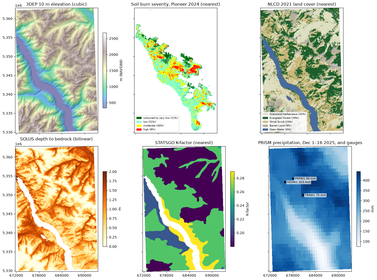
Accumulated precipitation at each gauge, against PRISM in the gauge’s cell. PRISM’s totals are known at the end of each day (12:00 UTC); hours without a report count as zero.
fig, axes = plt.subplots(1, hourly.sizes["geometry"], figsize=(15, 3.5), sharey=True, layout="constrained")
ends = prism.time_bounds.values[:, 1]
for i, ax in enumerate(axes):
    gauge = hourly.isel(geometry=i)
    in_window = gauge.precipitation.sel(time=slice(t0 + np.timedelta64(1, "h"), t1))
    cell = prism.precipitation.sel(x=xy.x.iloc[i], y=xy.y.iloc[i], method="nearest")
    ax.plot(in_window.time, in_window.fillna(0).cumsum("time"), label="gauge (hourly)")
    ax.plot(np.r_[t0, ends], np.r_[0, cell.cumsum("time").values], marker="o", ms=3, label="PRISM (daily)")
    ax.set_title(f"{gauge.station.item()}, {gauge.elevation.item():.0f} m")
    ax.xaxis.set_major_locator(plt.matplotlib.dates.DayLocator(interval=4))
    ax.xaxis.set_major_formatter(plt.matplotlib.dates.DateFormatter("%b %d"))
axes[0].set_ylabel("accumulated precipitation (mm)")
axes[0].legend(loc="upper left");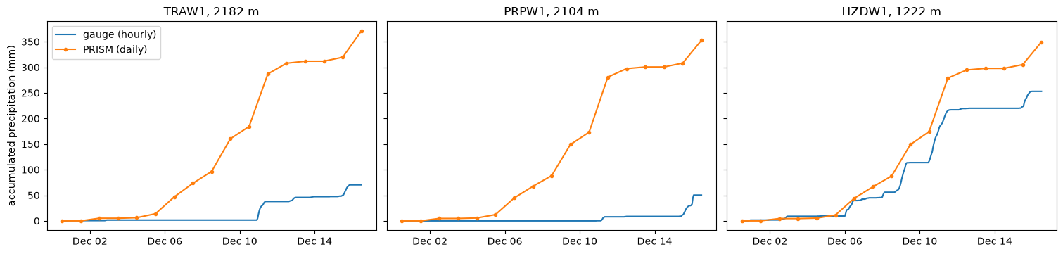
3. Landlab inputs with GDAL
GDAL reads the aligned store directly: each array is a subdataset with its CRS (_CRS), nodata (the Zarr fill_value) and, for packed soil layers, its scale_factor. Remote stores are read through /vsis3/ (or /vsicurl/), using the store’s consolidated metadata.
!{gdal_env} gdal raster info 'ZARR:"{aligned_vsis3}"' 2>/dev/null | grep NAME SUBDATASET_1_NAME=ZARR:"/vsis3/gaia/scratch/public/pioneer-10m/pioneer-10m.zarr":/dem/usgs10m/elevation
SUBDATASET_2_NAME=ZARR:"/vsis3/gaia/scratch/public/pioneer-10m/pioneer-10m.zarr":/rasters/burn-severity/burn_severity
SUBDATASET_3_NAME=ZARR:"/vsis3/gaia/scratch/public/pioneer-10m/pioneer-10m.zarr":/rasters/nlcd/landcover
SUBDATASET_4_NAME=ZARR:"/vsis3/gaia/scratch/public/pioneer-10m/pioneer-10m.zarr":/rasters/prism/precipitation
SUBDATASET_5_NAME=ZARR:"/vsis3/gaia/scratch/public/pioneer-10m/pioneer-10m.zarr":/rasters/prism/time_bounds
SUBDATASET_6_NAME=ZARR:"/vsis3/gaia/scratch/public/pioneer-10m/pioneer-10m.zarr":/rasters/prism/tmax
SUBDATASET_7_NAME=ZARR:"/vsis3/gaia/scratch/public/pioneer-10m/pioneer-10m.zarr":/rasters/prism/tmin
SUBDATASET_8_NAME=ZARR:"/vsis3/gaia/scratch/public/pioneer-10m/pioneer-10m.zarr":/soil/solus100/anylithicdpt
SUBDATASET_9_NAME=ZARR:"/vsis3/gaia/scratch/public/pioneer-10m/pioneer-10m.zarr":/soil/solus100/cec7
SUBDATASET_10_NAME=ZARR:"/vsis3/gaia/scratch/public/pioneer-10m/pioneer-10m.zarr":/soil/solus100/claytotal
SUBDATASET_11_NAME=ZARR:"/vsis3/gaia/scratch/public/pioneer-10m/pioneer-10m.zarr":/soil/solus100/dbovendry
SUBDATASET_12_NAME=ZARR:"/vsis3/gaia/scratch/public/pioneer-10m/pioneer-10m.zarr":/soil/solus100/ph1to1h2o
SUBDATASET_13_NAME=ZARR:"/vsis3/gaia/scratch/public/pioneer-10m/pioneer-10m.zarr":/soil/solus100/sandtotal
SUBDATASET_14_NAME=ZARR:"/vsis3/gaia/scratch/public/pioneer-10m/pioneer-10m.zarr":/soil/solus100/silttotal
SUBDATASET_15_NAME=ZARR:"/vsis3/gaia/scratch/public/pioneer-10m/pioneer-10m.zarr":/soil/statsgo/kffact
Since every raster is already on the contract grid, writing landlab’s files is a format conversion plus the contract’s nodata rules, a few gdal commands per layer. scripts
nodata (NaN, or a packed integer’s fill) becomes
-9999;soil layers are unscaled (
cec7is stored as tenths,ph1to1h2oanddbovendryas hundredths);burn severity keeps classes 2–4 and sets everything else to 1, with no nodata.
Layers the model reads as they are get their Landlab field names (topographic__elevation, burn__severity, landcover, kffact); the soil layers keep SOLUS’s names.
!{gdal_env} ../scripts/landlab-inputs.sh {aligned_vsis3} {landlab_dir}dem/usgs10m/elevation -> /tmp/pioneer-landlab/topographic__elevation.{tif,asc}
rasters/nlcd/landcover -> /tmp/pioneer-landlab/landcover.{tif,asc}
soil/statsgo/kffact -> /tmp/pioneer-landlab/kffact.{tif,asc}
soil/solus100/anylithicdpt -> /tmp/pioneer-landlab/anylithicdpt.{tif,asc}
soil/solus100/cec7 -> /tmp/pioneer-landlab/cec7.{tif,asc}
soil/solus100/claytotal -> /tmp/pioneer-landlab/claytotal.{tif,asc}
soil/solus100/dbovendry -> /tmp/pioneer-landlab/dbovendry.{tif,asc}
soil/solus100/ph1to1h2o -> /tmp/pioneer-landlab/ph1to1h2o.{tif,asc}
soil/solus100/sandtotal -> /tmp/pioneer-landlab/sandtotal.{tif,asc}
soil/solus100/silttotal -> /tmp/pioneer-landlab/silttotal.{tif,asc}
rasters/burn-severity/burn_severity -> /tmp/pioneer-landlab/burn__severity.{tif,asc}
!head -6 {landlab_dir}/topographic__elevation.asc | cut -c 1-60ncols 2182
nrows 3309
xllcorner 671690.000000000000
yllcorner 5329770.000000000000
cellsize 10.000000000000
NODATA_value -9999
The contract’s grid check: every output has the same CRS, transform, shape and nodata.
rows = []
for tif in sorted(Path(landlab_dir).glob("*.tif")):
    with rasterio.open(tif) as src:
        a = src.read(1, masked=True)
        rows.append({
            "layer": tif.stem, "crs": str(src.crs), "transform": tuple(src.transform)[:6],
            "shape": src.shape, "nodata": "none" if src.nodata is None else src.nodata,
            "min": a.min(), "max": a.max(),
            "nodata cells": int(a.mask.sum()),
        })
check = pd.DataFrame(rows).set_index("layer")
assert check[["crs", "transform", "shape"]].nunique().eq(1).all()
check.drop(columns="transform")